
‘Ring and Strip Method of Fire Management’ in Balliguda Forest Division, Odisha
By Vishwanath Neelannavar, IFS
Forest fires globally are considered as one of the major factors of climate change, bio-diversity loss, Habiatat destruction of tiny organisms and increase in global temperature due to production of biological carbon and greenhouse gasses. In the tropical deciduous forests of Orissa, fire is a recurrent phenomenon due to higher levels of water stress during summer. In Balliguda division due to traditional land use practices by local population, and dependency on the forest for Minor Forest Produce like Kendu (Tendu), Mahua flower collection etc have intensified the fire incidences to a large extent. Forest fires in Balliguda are mostly anthropogenic in nature. Use of Satellite data of sensors like SNPP, MODIS to identify the active fire points based on brightness temperature levels recorded in short wave and thermal IR wavelength bands has increased the accuracy and the number of fire points in India. The number of channels or bands in MODIS is 36 and of these bands 20-36 falls under thermal bands having a resolution of 1 km and SNPP 375 meter daily coverage. The fires which have an extent of 1-2 ha or more are only picked up by the satellite. This has led to increase in the recording of fire points correspondingly. The improvement in reporting and dissemination of the information has reduced the response time for management of the forest fire in the field.
Introduction
In 2017, Odisha state was on top with respect to number of forest fire points as per FSI (Forest Survey of India) reports. In Odisha, Balliguda forest division was at the top position with 3165 number of fire points as per the FSI reports. In order to address the issue, series of meetings and brain storming sessions were held at division level and at range level involving the villagers, watchers and para staff of the ranges. The brainstorming sessions were held in each Range Office with local staff, fire squads, and the para staffs. Their valuable experience and practical knowledge was harvested to a great extent. The reasons for forest fire were identified and possible ways of addressing the situation was analysed. The best possible solutions were zeroed upon. The reasons of the forest fire in Balliguda Division were as follows
- Collection of Mahua Flowers
- Collection of Kendu (Tendu) leaves
- Podu/Shifting Cultivation
- Grazing in forest areas
- Turmeric Cultivation.
Balliguda forest Division comprises of 07 number Ranges, 24 No’s of Sections and 75 number of beats the geographical area of the division of 5627.45 sqkm. For the control of Forest fire, Control Room runs 24×7 hours in Division office, and in all Range office of Balliguda Forest Division. The contact number of the division office and the range office has been displayed in the respective offices and in all the important locations govt buildings of the villages based on the intensity of the fire.
Methodology
The top two issues ie., Collection of the Mahua flowers and the Kendu leaves were taken up and started proper planning in advance for 2018 year fire season. These two reasons directly impact on the livelihood of the local villagers and therefore it is a very sensitive issue to be tackled with. The mahua areas and the command areas of the Kendu leaves were identified based on the severity of forest fire and vicinity to the forest areas which are sensitive for forest fire.
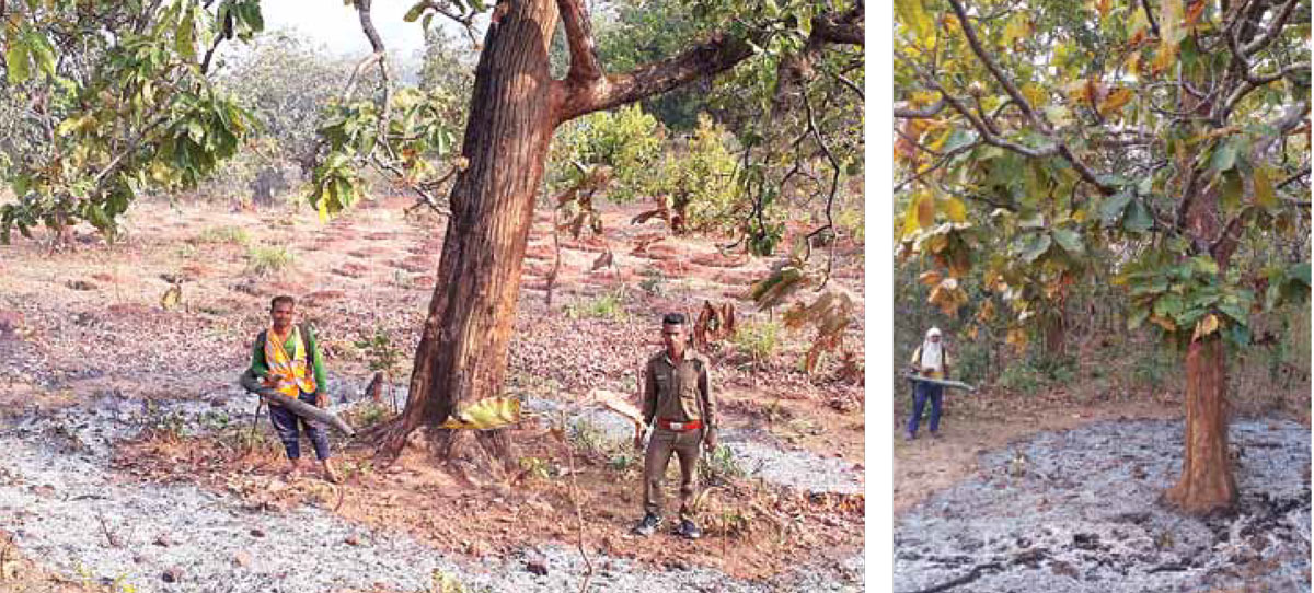
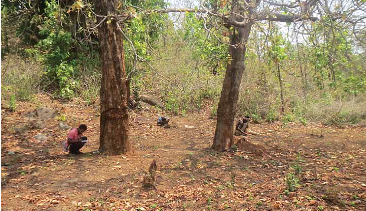
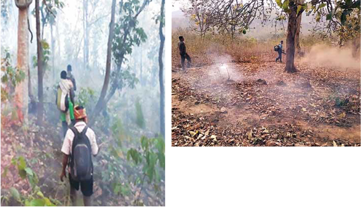
It was decided to go for control burning i.e ‘Ring method and Strip method’ in advance in all sensitive areas. The dried and fallen leaves would be blown away using the blowers, the resultant shape would be like a ring all along the tree. In case of strip method where more number of trees are there in single location, the whole area is taken and one long strip of dry leaves would be blown away giving the shape of a strip. The blowers were used for the control burning method so that the burning materials ie the dry leaves were removed thereby breaking the fire triangle.
The contact details of the control room of the division and the range offices were displayed at all govt institutions and other nearby buildings for information to locals so that they can contact forest officials for the blowers. All the staffs were prepared in advance for the upcoming fire season with necessary human resources and equipments to combat the forest fire in the division. The required training and skill was imparted to the frontline staff for better execution of the work. The details of the method is elucidated hereunder.
The local tribal population depends on their livelihood on Mahua flower collection during fire season. They will collect the flowers from the ground surface after they are matured and fall to the ground. The surface during this period is full of dried and fallen leaves, which makes them difficult for collecting the same. Therefore they burn the surface so that it is very easy for collection of the leaves. The tribals have designated mahua trees and no other person can collect the flowers from that trees. The method they adopt is very destructive and harmful to the forest and to the wildlife.
The tribals kindle the surface in the evening time and visit the same spot next day morning. By this time, the lowers will fall of due to the smoke and the surface would be smooth for collection of the flowers. The fire so kindled would eventually spread to the nearby forest and other locations uncontrolled way, making it very difficult and cumbersome to the staff to douse the fire. In order to address the situation all the mahua trees were identified well in advance as per the experience of 2017 fire season. Total 12000 trees were identified and each tree was identified with GPS location in villages, the individual tree is owned by particular family group of communities. The intervention helped is advance burning through ring method and strip method, as per the site demand, which are near to the vicinity of forest areas.
In Kendu (Tendu) leaves areas, there is the designated command areas from where the tribals collect the kendu leaves by cutting the kendu bushes. The bush will develop new fresh leaves after 45 days from the date of bush cutting. Further, in order to get the more leaves, the villagers go to forest in evening areas and kindle fire in other areas including revenue land and tin forest land, to get fresh kendu leaves.
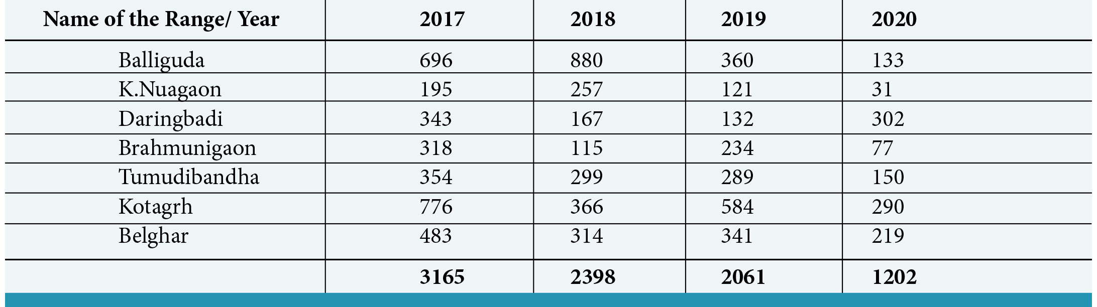
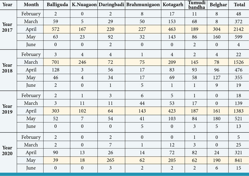
It is believed that the leaves which sprouts out of burned kendu leaves has better quality than leaves from bush cutting. Our intervention here was that the command areas and other lands of Kendu (Tendu) leaves were identified in coordination with kendu leaves range staff. The operation is time bound and this time was utilised for control burning (Strip method) in co-ordination with villagers, bush cutters and other local villagers. This helped in controlling the un-scientific forest fire by kendu leaves collectors and the local people to get more profit. The comparative analysis of last four years is given in the table below.
Table
Use of Q Gis in Control Room at Division Office
During Fire Season we adopted Rapid Fire alert System in Balliguda forest Division. Data Entry operators from control room, download the CSV file from the NASA web site (https://firms.modaps. eosdis.nasa.gov/ active_fire/#firms) and FSI Website (http://fsi.nic.in) on a daily basis. These CSV files were fed into the QGIS software, to identify the Range, Section, Beat, Land status, the nearest village and the shortest road or route possible.
The top sheet images are shared through what’sApp group and text massages along with this they are also informed via phone calls. Excel sheet and the toposheet image with firepoint location is also shared in the group. This has helped the frontline field staffs to reach the required location and to extinguish the forest fire as soon as possible. This has reduced considerable time gap in the field for fire management
Results and discussion
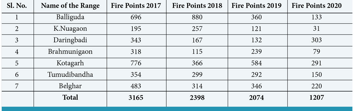
The intervention helped is considerable reduction in fire points from 3165 in 2017 fire season to 2398, 2074 and 1207 in 2018, 2019 and 2020 fire seasons respectively. The Ring and Strip method will definitely reduce the number of fire points thereby the corresponding ill effects to the forest and the wildlife has been reduced accordingly. The fire intervention for podu / shifting cultivation would further reduce the fire menace in the division. The fire points recived from the FSI is given in Table No 1 as under. Use of Q-GIS &Whats app has reduced time gap from 4-5 hour (previously) to 30 minutes, to extinguish forest fire in the field.
Table No.1: Total Fire for the Year 2017 to 2020 as per FSI data
The considerable reduction is directly attributed to the intervention that is Ring and Strip method of fire management in the division. This has not only helped to reduce the number of fire points but also the area burnt has also been reduced considerably.
The locals have welcomed the intervention as this is not affecting their livelihood and instead their job is made easy. The GPS coordinates of all the trees which are very sensitive to the fire have been identified and recorded for the future reference.
Graph No. 1: Month-wise fire Abstract from 2017 to 2020 in Balliguda forest division
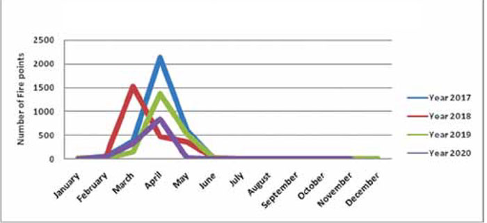
Table No 2: Month wise Fire Abstract from 2017 to 2020 in Balliguda division
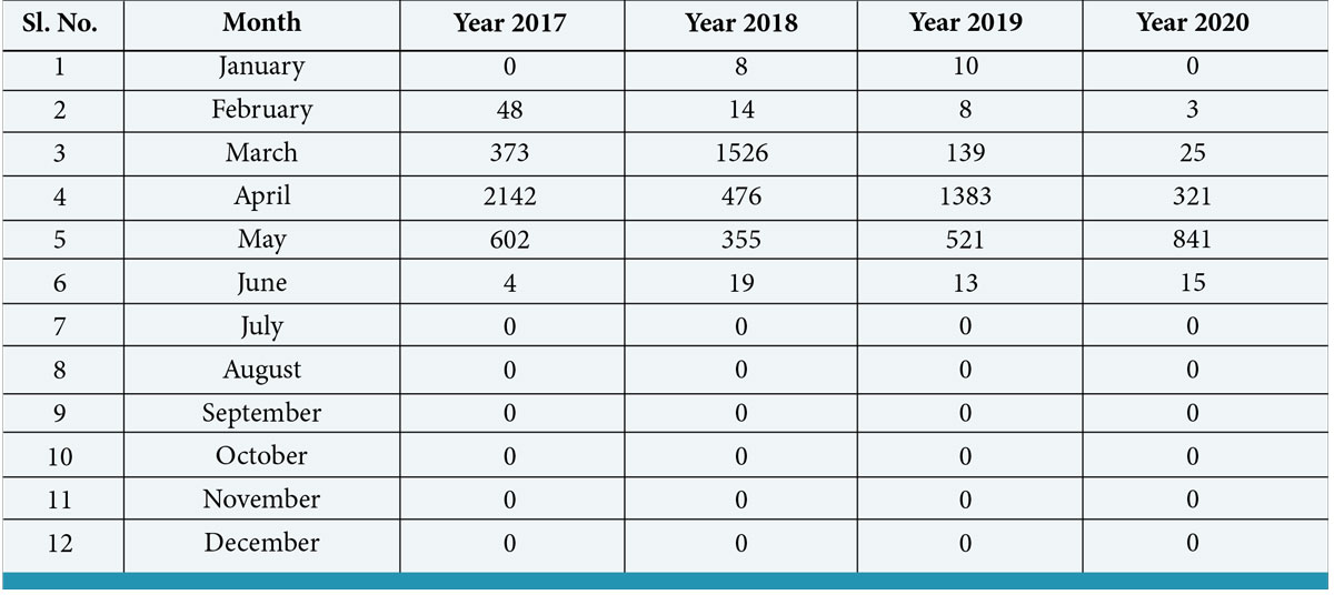
The fire dynamics in the division is directly related to the livelihood activities of the local people in the region. When we analyze the correlation between the peak fire points and the livelihood activities, it is coinciding with the activities like Mahua flower collection and Kendu leaves collection. The two peaks in the graph are representing the livelihood activites of the local people which corresponds to the month. It is pertinent to mention that the flowering of mahua tree starts from last week of February to third week of March approximately. Therefore there is direct correlation between flowering season and the number of fire points.
The kendu leaves bush cutting starts from the first week of march to 25th of March depending on the suitable condition. Where ever kendu leaves bushes are available both inside and outside the command areas, the locals kindles the forest floor in order to fetch more income by selling the leaves. This activity is also coinciding with the fire points. Therefore there is direct correlation with the month and with the fire points.
Therefore the intervention by the division has reducued the fire points considerabley and further fine tuning of the Mahua tree locations and the command area of the kendu leaves will definitely improve the fire status in the division.
Graph No 2: Range wise fire Abstract from 2017-2020
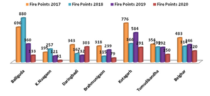
Table No 3: Month wise and Range wise abstract of fire from 2017-2020
Related Posts

Aloevera (Aloe barbandensis) | By : R. K. Nigam
Aloevera (Aloe barbandensis) By R. K. Nigam Aloe-vera is a succulent plant species, evergreen…

Vultures of Madhya Pradesh | By – Aishwarya Laghate & Sunny Joshi
Vultures of Madhya Pradesh By Aishwarya Laghate, Sunny Joshi Vultures are nature’s most efficient…

Floating Nest- Little Grebe | By – Sachin Matkar
Floating Nest- Little Grebe By Sachin Matkar Floating nest-Grebes nest at the water’s edge,…

Scorpions: the enigmatic arachnids, with notes on scorpion diversity in MP | By – Sudheer Kumar Jena, Pragya Pandey & Pratyush P. Mohapatra
Scorpions: the enigmatic arachnids, with notes on scorpion diversity in MP By Sudheer Kumar…